Sunday, June 8, 2025

The In Between

The stay in Corre allowed us a little bit of time for some sightseeing in the vicinity. A sign at an intersection in Corre alerted us that the nearby village of Jonvelle was the site of a Gallo-Roman archeological site. Something that old was a sure draw for us, and a 9 km bike ride didn't seem too difficult to tackle, even with the hills in the vicinity. Of course, we should have known that Google Maps would incorporate an unimproved path through a farm field into its suggested bike route, so we ended up biking a bit further to avoid getting mired on a grassy path.

We were fortunate to have available time on Sunday, June 1, because at this time of year the archeological museum was only open on Sundays and holidays. The discovery of the baths of a Roman villa 1 km to the south of the village of Jonvelle was made in 1968 by Abbot Emile Descourviers of the local parish. The villa was constructed at the end of the 1st century CE and seems to have existed until the barbarian invasions of the 4th century. The baths were the most intact remains discovered. Around 1990, a tile workshop was discovered close-by, but as those ruins are still on private land, they were not available for viewing.

The ruins of the Roman bath are part of a multi-purpose museum.
The building at upper left covers and protects the remains of the bath,
as well as other archeological objects found during excavations in the
area. The building at right houses a small, but rather impressive museum
with artifacts ranging from the Neolithic to the Merovingian. The open
door of that building leads to an exhibit on machines from the 19th to the
early 20th centuries. A third building has antique farming machinery and
is under development as exhibit space.

Upper: The Roman Baths, the changing room and
frigidarium at the foreground of the photo, and the
areas for the warm and hot baths toward the top.
Lower: The pride of the museum is the intact mosaic
in the floor of the frigidarium. The dolphins in two of the
corners are an interesting Mediterranean touch, as there
are definitely no dolphins in the Petite Saone River.

Artifacts have been found in the general area, including bournes
from the Louis XIV area and older that mark administrative boundaries,
and this sundial with the rather philosophical inscription, "Time passes; 
death comes; the earth remains."

The marina was probably the most active part of Corre. Agriculture is also an important part of the local economy, but otherwise, it is a rather sleepy town. We're fortunate that it had a small-to-moderate sized grocery store--and even more fortunate that we were able to arrange for a rental car there. The marina had a nice, family-run restaurant that we took advantage of on our arrival day in Corre (and also again with cousin Frank the night before we departed for the Canal des Vosges.)


Upper: the view from our mooring in Marina de Corre.
Lower: moored in Corre. We don't usually have to 
moor in this kind of perpendicular-to-the-dock orientation,
 so it required all of Lon's boating skills to avoid
 making the docking a "contact sport."

The June 3 drive to Epinal only took an hour and our meet-up with Frank went seamlessly. Because we couldn't immediately check into our Airbnb apartment, we took advantage of the time to have lunch in the center of town and briefly walk a few of Epinal's streets. 

Epinal is the capital of the Vosges department in the heart of the Grand-Est region of France. The original city was formed during the Carolingian era, and during the Middle Ages and the modern era, Epinal protected the Duchy of Lorraine against attacks by Burgundians and the French. It derived its wealth from the wood, paper, and textiles industries until the Thirty Years' War of the 17th century, when its city walls and castle were destroyed by the armies of Louis XIV of France. It eventually became part of France in 1766. Epinal was annexed by Prussia after the Franco-Prussian War of 1870-71, and it was about this time that the Canal des Vosges was built.

Two branches of the Moselle River run through Epinal.
A whitewater kayak course has been set up on one
of the branches in the center city and is the site of
international races.

The Place des Vosges was the political and economic hub of the city. It was the liveliest place
in town when we did "Round 2" of our city walk later in the evening of June 3.

Frank atop the remains of the town ramparts. The ramparts were erected in the 13th century,
modified in the 15th, and were torn down at the time of Louis XIV's siege of Epinal.

"Liberté" is a sculpture from 1989 to celebrate the
bicentennial of the French Revolution. The two fingers
are symbolic of the idea that the quest for liberty
is never-ending.

The "Quartier du chapitre" near the Saint Maurice Basilica 
contained an alley lined with the mansions of noblewomen (above), depicted
comically in a neighborhood fresco (top photo).

A side view of the Saint Maurice Basilica (11th-13th century).

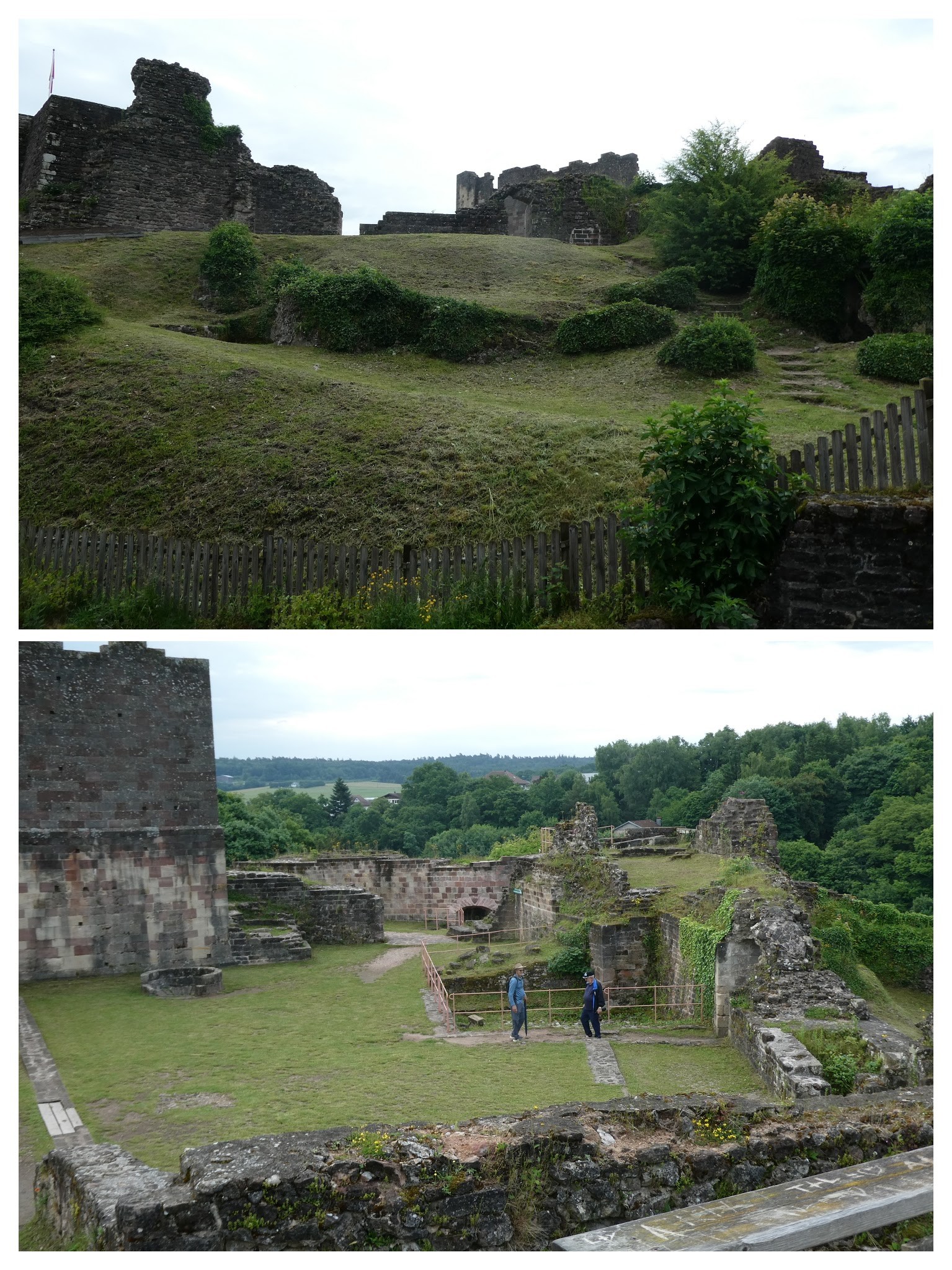
The idea of also walking to the ruins of the city chateau on a hill above the town was a bit too much for one day, so as we began our drive to the city of Colmar on June 4, we made a brief detour to take in the castle grounds.

The Chateau de Epinal was built by the bishops of the city of Metz in
the 13th century. Its height provided for wonderful surveillance over the
Moselle River valley. It was destroyed by the troops of Louis XIV in 1670.
Substantial excavations were carried out in 1980. Upper: looking up at
the castle remains. Lower: Lon and Frank in the inner courtyard of the 
castle grounds.

We enjoyed our climb and wandering through the ruins.

The drive to Colmar was an "up and over" experience through the Vosges mountains--really more like glorified high hills. It was a green and beautiful drive, if somewhat wet and rainy from time-to-time, and with several stretches of switchbacks in the road, it took about 2 hours for us to reach the city from Epinal.

Lon and I had been to Colmar in 2019, as a land "side trip" during our cruise that summer on the Rhon au Rhin Canal. Frank was anxious to see the city because of the city name's importance in Cedar/Wojtowicz family history. Frank's grandfather Wasyl Cedar and Lon's grandfather Nick Wojtowicz, both employees of the Canadian railroad, had an argument in 1916 in the village of Colmar, Saskatchewan, which resulted in a rift in the family and Lon's grandfather's move to St. Paul, Minnesota. Despite the fact that Colmar, France had no bearing on the argument, the name was a sufficient reason to visit this beautiful French town.

Colmar is famous for its well-preserved old town, full of medieval and Renaissance timbered buildings. Due to being in Alsace and close to the German border, it has moved between France and Germany many times over the centuries, so the German language and German culinary influences make themselves known. Colmar is on the Alsatian Wine Route--a 170-kilometer-long road that crosses the main wine producing areas of the region--and considers itself to be the capital of Alsatian wine.

Some general street shots of Colmar. Left: The 13th century Collegiate Saint Martin is visible at the top of the photo. The picture at the upper right is of the building where our Airbnb apartment was located. The apartment was modernized and beautiful, and the location in the heart of town couldn't have been better.

More Colmar. Definitely a tourist town, but it wasn't overly
crowded when we were there.

Upper: Lon and Frank just outside a crepes and 
pizza/tarte flambé restaurant where we enjoyed
lunch and evening dessert crepes on the 4th.
Wonderful owners and great food.
Lower: One of Colmar's main streets.

Everywhere you looked there were wonderful decorative
elements on buildings.

Lon and Frank prove that they can be in (a) Colmar without fighting.

And again . . . leaving no doubt where they are.

The final stop of our road trip adventures "in between" our just-finished cruise up the Petite Saone River, and our yet-to-be-completed cruise on the Canal des Vosges, was the village of Eguisheim, just outside of Colmar and on our route back to the marina in Corre. Eguisheim had come to my attention recently courtesy of an on-line travel article that talked about the unusual circular layout of its medieval center. It turned out to be a pretty place, but as one of the "Most Beautiful Villages in France" and as part of a Rick Steves' tour itinerary, it was definitely "touristy" and not "off-the-beaten-path."

An aerial photo of Eguisheim on a brochure from 
the Tourist Office showing its circular design.
 
Like Colmar, Eguisheim was full of beautiful timbered buildings.

Upper: "Most Beautiful Villages" perhaps have a contractual obligation to
have lots of flowers.
Lower: Eguisheim is on the Alsatian Wine Route, and vintners and their
caves were everywhere you looked.

Beauty can be in the little details. Upper: an arch from 1599 encompasses
the (contractually mandated?) flowers.
Lower: Houses in the Middle Ages were routinely marked with the date
of the building (1680), the initials of the couple that owned the house
 (GHM), and a reference to Jesus Christ (IHS).

Remnants of a castle, and a chapel (the pink building) 
dedicated to Bruno of Eguisheim, who became Pope
Leon IX (1049-1054). The storks seem to like the bell tower.

Arrival back in Corre on June 5 involved taking advantage of having a rental car to shop for the heavy groceries. On the morning of June 7, we left Marina de Corre, left the Petite Saone River, left the "in between", and entered the Canal des Vosges. 

Sunday, June 1, 2025

At a Crossroads

Yesterday, May 31, we arrived at the village of Corre, at the junction of the northern end of the navigable Petite Saone River and the southern end of the Canal des Vosges. We were able to secure a mooring spot for CARIB in the very nice Port de Plaisance, where she will stay for a week. We'll meet up with Lon's cousin Frank in Epinal on Tuesday, see what we can of that town during an overnight stay, then continue on to the Alsace region for some additional "touristing" in Colmar and its environs before returning to Corre on Thursday. Friday will be cruise preparation day as we restock the groceries and prepare to start heading north on the Canal des Vosges on Saturday, June 7.

The overwhelming impression of our past few days cruising the northern end of the Petite Saone River can best be described as "serene." It was a very rural area, alternately wooded and agricultural. The gently flowing river continued to narrow as we headed north, and in many stretches was not much wider than a canal. The towns and villages along the route were mostly just small farming communities and/or involved with water-focused tourism, without much strategic importance historically. As a result, the occasional older buildings that could be spotted were simply vestiges of daily life "back in the day" and not part of any grand historical events. It was difficult to ferret out information on most of the towns and villages--there wasn't much on the internet and most tourist offices were not open and wouldn't be until "the season" started on June 1. We really missed not having access to walking tour maps and guides.

We left Ray-sur-Saone on Tuesday, May 27. Our destination for the day was Scey-sur Saone and it turned out to be a longer-than-usual cruising day for us at a bit over 5 hours. The twenty-two kilometers of distance wasn't so much, but 6 lock passages, 1 tunnel, and more than the usual amount of reduced speed zones added to the length of the cruising day.

Visible from the river was Rupt-sur-Saone, with its 17th
century church and its castle with a 12th century keep. Sad to
say, there was no suitable mooring near the village.

We passed through the 19th century, 681-meter-long Saint-Albin Tunnel just a few
 kilometers shy of  Scey-sur-Saone. It is classified as a Historic Monument.
 By the time it was finished in the 19th century, trains had already begun to surpass
 barges as a mode of transport for goods and people.

The Port de Plaisance on Scey's diversion canal could not handle our boat, so we "hung a left" down the arm of the Petite Saone to a wood and metal quay closer to the town itself. 

Our mooring in Scey-sur-Saone was lovely and peaceful, but Lon's estimation of a safe approach
to the landing didn't go over very well with some fisherman on the shore of the nearby campground.

We couldn't see the fishermen because of the trees as we made our way to the mooring, but they were most unhappy with our distance from the shore. In fact, one of them followed us all the way to the quay and continued to berate us as we were trying to get tied up. French may have been historically known as the language of diplomacy, but it was anything but diplomatic in the mouth of the angry man. As our attempts to apologize were not working, and to avoid escalating the situation, I reverted to using another language--cold, hard cash. Money does, indeed, talk. It was amazing how quickly an offer of compensation for their trouble (aka, bribe) quieted things down. Happy Hour could not come too soon that day.

We stayed in Scey-sur-Saone on the 28th. It was a rainy day, and we hoped to have a chance to look around this town that is classified as a "City of Character" in Burgundy-Franche-Comte, even if it had to be done from under an umbrella.

Turreted buildings, lavoirs, glimpses of art preserved on old buildings, and the town church.
It was quiet--maybe because of the weather.

This unusual building in Scey, a former foundry, is identified in Google Maps with the German
name "Haus der vielen Gesichter", the house of many faces. The aura conveyed by
the figures placed on the exterior walls is pure Halloween, not to mention a spooky
 "Chucky" doll or two in one of its windows. 

Thursday, May 29, was Ascension Day, a holiday in France. Fortunately, it was not one of those days when the locks are shut down, so we had no trouble during the short cruise (less than 2 hours) to our next destination, Port-sur-Saone. Its name says it all--it's been a port since at least Roman times, and ruins of a Roman villa were excavated in the town earlier this year. The Saone diversion canal through Port-sur-Saone was completed in the late 1800's, not long before river transport began to diminish in importance. Today, Port-sur-Saone has a Port de Plaisance and is a base for at least one holiday rental boat company.

We saw lots of camping along the river--and had a lot of 
fishing poles to look out for.

Sainte-Etienne church rises above the surrounding buildings in
Port-sur-Saone. In past years we've seen lots of 12th and 13th century
 churches. In this part of France, the 17th century seems to have been the
period for a "church replacement" building boom.

Building art--Fresco of the Rights of Man, honoring those who have
fought for human rights issues.

Left: another town, another lavoir.
Right: A long quay made mooring easy.

The building was formerly a hotel, but didn't seem to be open.
 "1588" above the door identifies just how old it is.

We had a stop picked out for the next day, Friday May 30, at one of the few moorings between Port-sur-Saone and Corre. We'd been seeing a fair number of holiday rental boats on the Petite Saone, so I was a little concerned about whether we'd find an open spot. Once we start cruising, we tend to keep going until we get to our overnight mooring, but many boaters take a midday break for lunch, and this can make mooring spaces trickier to come by. We ultimately decided to take a "bird in the hand" approach and be open to stopping earlier than planned if we saw space on a decent mooring. Our first option was full, but we were fortunate to find space at the second option, a restaurant quay in the village of Fouchécourt. Even better, the restaurant waived the small mooring fee that we were expecting to pay. We were glad for the short cruising day, because it got very warm by the afternoon.

Upper: the restaurant maintained a lovely park area.
Lower: the "Petit Port" adjacent to the restaurant/park grounds. 
A food truck was brought in for Friday pizza night. It was
 well-attended by the French, and had we not had pizza the night
 before, we might have joined in the fun.

The restaurant and port were the busiest places in town. There wasn't much to see in Fouchécourt aside from the church and residential buildings. Because we were tied up by noon, we had plenty of time to finally get the bicycles down and see what was going on in a couple of the neighboring villages, Baulay and Montureux-les-Baulay.

The village of Baulay had turned their lavoir into an exhibition
space. The display above recognized the soldiers from the region
who died fighting with Lafayette in the U.S. Revolutionary War.
 The small rowboat was constructed starting in 2010, and was
 a replica of a boat associated with the French troop carrier
 ship--the Hermoine--that brought French soldiers to Yorktown.

Baulay was proud of the activities of the French Resistance in Baulay in 1944. The Paris-Belfort line ran through Baulay, and was used by the Germans to transport personnel to concentration camps and to move equipment. Derailments by the Resistance from July to September 1944 shut down this pipeline, with no loss of life, until the Allies arrived on September 12, 1944.

Upper: La Tranché de Baulay was the site of derailment upon derailment.
Lower: The town created the display for its 70th anniversary commemorations
in 2014.

Montureux-les-Baulay was primarily a farming community, but it did have
a lovely mansion that seemed to be serving as an events center, and a very
small church. The bell tower of the church had survived since the 13th 
century, but the rest of the church was an 18th century reconstruction.

The local Montureux lavoir was lovingly maintained.

Saturday, May 31, was another warm day, but it was pleasant cruising in the morning hours. Same old, same old--nature and small villages.

Mama stork feeds her baby. 

Garden gnomes keeping watch lockside.

The 3 locks of the day were all quite deep. I'm glad
to be as tall as I am, because reaching the bollards
in or on the lock wall was sometimes quite a stretch.

Another castle seen from the river--a nice break from trees and cows.

Tomorrow we get CARIB ready to receive our visitor.

Monday, May 26, 2025

(Mostly) Short and Sweet

We’re now into our 5th day of cruising on the Petite Saone River, and are spending it as a “rest day” in the village of Ray-sur-Saone. "Rest" is a bit of a misnomer, as it’s not as though our schedule has been grueling. In fact, we are making a conscientious effort not to over-do the number of hours we cruise on any particular day. Our immediate, short-term cruising goal is to be in the town of Corre—the furthest point of navigation on the Petite Saone River, and the start of the Canal de Vosges—by no later than June 2. Lon’s cousin Frank arrives in France from Canada on June 3 and will take a train to Epinal. We had originally hoped to cruise on CARIB to Epinal in time to meet him there, but our departure delay caused by Lon’s fall means that we will rent a car in Corre and drive to Epinal instead. In constructing a cruising itinerary to fit this short-term goal, our general outlook is that we’re not in a hurry, and if we arrive at a day’s cruising destination no later than early afternoon, we’ll be well-rested and easily able to spend time investigating where we’re at. Of course, reality can sometimes collide with the “ideal”, and so adjustments must be made. One of the biggest “reality checks” is the location and suitability of mooring spots.

We’ve found that finding appropriate mooring spots on rivers can be more challenging than finding a place to stop on canals. At least on a canal we have the option of pulling over to the side of the channel and driving stakes to hold our lines if we are unable to find a mooring quay or pontoon. Rivers with too much vegetation on their banks and unpredictable water depths remove that as an option. In a pinch we could perhaps find an off-channel pond in which to drop anchor, but that’s more effort than I care to contemplate. We’ve been on the lower 2/3 of the Petite Saone before—in 2021 we had to turn around just north of our current mooring when the Canal de Vosges developed a leak—and are looking to mix things up a bit in terms of our daily stops. This means that we are on the lookout for moorings that: (1) can accommodate a 21-meter barge (2) are in towns that we haven’t been in before and are interested in exploring and/or have shopping options (as groceries can be a challenge), and (3) that are not-too-distant from the previous mooring location.

If we had a smaller boat it would definitely be easier to find mooring
spots. Many of the haltes and ports are designed for boats that are
less than 12-15 meters long, such as this halte in Arc-les-Gray.

Friday, May 23, was a beautiful—if somewhat cool—day for our 3-hour cruise from Pontailler-sur-Saone to the village of Mantoche, a few kilometers south of the much larger town of Gray. When we cruised past Mantoche in 2021 on our way to moor in the town of Gray, we’d noted the quality of the quay and loved the location by the town’s chateau.


On the way to Mantoche we passed the junction of the Petite Saone with the 
Canal entre Champagne et Bourgogne.

Our approach to Mantoche. Although there were two boats on the town quay, they were
far enough apart that we would be able to slip between them. So far, so good. What we weren't entirely sure about going in was the depth of the water. Most reports we'd seen said that the depth was one
meter at the downstream end (and less upstream). As our water draft is 1.1 meters, we were a bit
nervous about possible grounding. Happily, our concerns did not come to fruition.

Panorama of the Chateau de Mantoche, as seen from the park fronting the boat docking
area. The current chateau is primarily an 18th century restoration and enlargement of an
older fortified castle that was destroyed in the early 17th century.

The 12th century church that originally sat on this site is no
more, having been rebuilt in the early 18th century.

The town was rather quiet on that Friday night, but we were able to take advantage of dinner out at what appeared to be the sole restaurant in the town. Very friendly owners. "The Capitainerie" also doubled as a small--very small--grocery store. 

Our cruise on Saturday, May 24, was even shorter. We decided not to stop in Gray this year, having stopped there twice in 2021, and as we didn't yet need to restock the larder, we continued on a few more kilometers to the village of Rigny. Our cruising time was a grand total of 2 hours. 

Putting Gray "in our rearview mirror", so to speak. We enjoyed
touring the town a few years ago, but didn't expect it had changed
in any substantial way to make another visit necessary.
 
Are the residents having trouble with English-speaking boaters
trying to stop where they're not supposed to? We saw a few
signs like this--using the English word "boat" rather
than the French word "bateau'"--on one stretch of the waterway.

Our mooring on a diversion canal on the outskirts of Rigny. The
concrete quay was a bit longer than the reported 15-meter length, 
and it worked well enough for an overnight stop. Until we were nearly
abreast of the quay we weren't sure that it had been mowed.
Thankfully, we didn't have to put our newly purchased scythe to work.

The Rigny of today is a small, quiet, non-descript little village. Its history seems to have been one of centuries of being caught in the middle of disputes between one political faction or another. So, nothing especially out of the ordinary in the experience of French villages!

The church of Saint-Etienne in Rigny. The 18th C high
altarpiece is listed as a Historic Monument. 

Left: roses and old buildings are a potent esthetic combination.
Right: Many of the village WWI war memorials in this part of
France are topped by the "Gallic Rooster," a national
symbol of France. Its origin goes back to the Middle Ages, a play
on words between the Latin word "gallus", meaning an inhabitant
of Gaul--but also meaning "rooster". 

The main "claim to fame" of Rigny these days, at least according to the cruising guide, is the gourmet meals served in the Chateau de Rigny, which is now a B&B.

Upper: part of the Chateau de Rigny complex
Lower: the new bridge (since 2010) to Rigny that crosses
 the Saone. A previous metal bridge was badly damaged
 in WWII, and wooden repairs collapsed under a herd
 of cows in the 1950's. 

May 25--cruising day 4-- is where our "short day" aspirations broke down, due to entering a sort of "desert" with respect to mooring options for barges. The cruising itself was nice--after early rain the sun came out. As has been true since we left Auxonne, the route has us alternating between stretches of the actual river and "diversion canals" which bypass portions of the river and shorten the travel.

Lower: A "porte de guard" on one of the diversion canals.
 The downstream ends of the diversion canals typically
 have a lock, and the upstream ends a "guard gate,"
 the doors of which get closed in the event of flooding.
Upper: unusually, the diversion canal just south of 
Ray-sur-Saone  had a "guard lock" at about the
 midpoint of the canal--and no "guard gate"--to
 deal with flooding situations. 

Left: approaching the 620-meter Tunnel de Savoyeux. The most difficult part of the cruise
was the deep lock we had to deal with prior to the tunnel.
Right: in the Tunnel de Savoyeux. A "piece of cake" as far as tunnels go. When you've gone
through tunnels that are 5 km (3 miles) long (as we did in 2021), 620 meters
 of well-lit tunnel is nothing to worry about.

Believe it or not, Lon is actually enjoying the boating. It's just
that he's about to enter the tunnel and he's concentrating
on staying off the walls of the relatively narrow passageways 
and tunnel.

In 2021, we moored (by pounding stakes) against the bank of the canal fairly close to the tunnel exit. There's a port nearby, but they don't accommodate barges. At that time, the bank was nicely mowed. This year? Not so much. It's a good thing that we hadn't intended on staying there, but having to push on to the next possible mooring site at Ray-sur-Saone made for a longish 5.5-hour cruising day.

To get to Ray-sur-Saone you have to "make a left turn" from the normal cruise route that follows a deviation canal in order to travel about 1 km down a stretch of the actual Petite Saone River. As with Mantoche, there were advisories of depths of 1 meter in this 1-km stretch. We'd seen that other barges of our size had successfully made it to Ray, so we thought it was worth a try. We very slowly made our way amongst the river buoys that marked the navigable channel and docked without seeming to have ever been in danger of running aground. As it was already mid-afternoon by this point, and it had started spitting rain, we decided to stay in Ray for a day for recovery and to give us time to walk around the town.

Top: Approaching Ray-sur-Soane and avoiding the shoals to our right.
Bottom: our view from CARIB. The church tower and the Chateau de
Ray have a birds-eye view of the village.

An artistic "Welcome to Ray sur Saone".

The washhouse of 1844 was beautifully designed
and maintained.

The Church of Saint Pancras has a choir that was
built before 1224 and side chapels from the 15th 
century. The Romanesque heritage is evident in the
interior, which also contains several historically listed
works of art from the 16th and 17th centuries.

To get to the castle and the upper town one must climb.
The Petite Saone is visible at the upper portion of the photo.

The Chateau de Ray, an 18th century construction on the site of the medieval fortress that had been
 destroyed in the wars of the 17th century. The castle gardens were open for visitors, but at this point
in the year, the interior of the castle is only open for tours on weekends. The last owner of the
castle donated it to the Haute-Saone Department in 2015.

Pat climbing stairs near one of the two towers
of the castle that date back to the Middle Ages.

Our cruising itinerary tomorrow will take us beyond our "turn-around" point of 2021.