Thursday, August 12, 2021

Summer Makes an Appearance

It's August 12, and this is the second day in a row where it's been sunny and the temperature has exceeded 80 degrees F. I'm not sure that we quite know what to do with this suddenly summer-like weather.  It was a beautiful morning for cruising as we left Verdun after a 2-day hiatus.

The water was like glass as we left Verdun


Even the cows were in the summer spirit. One adult cow being
followed by many calves looked like a summer "field" trip was
taking place with the youngsters.

When we left Saint Mihiel on Sunday, August 8, it was still cloudy, cool, and intermittently wet. One interesting aspect of the canal from that date is that the locks have all been manual locks--no automation in sight. Fortunately, it is not we who have had to put in the effort. We have to call the vnf planning center a day ahead of time to give them our cruising schedule for the following day, i.e., when we are starting our day and where we are planning to stop. They then schedule staff to be at the locks to get us through.

Our helpful vnf employee on August 8.

Even with the vnf on site, things did not always proceed smoothly.
On August 9 there was a bit of a weed problem that kept the exit
gates from fully retracting, so we were stuck in
the lock until the weed was cleared away.

At a few of the locks today Lon was able to get off
the boat and give the vnf an assist in closing the 
entrance gates.

We've now completed manual locks 11 through 25, and only have 2 more to go before they revert back to automated locks that will operate with our Telecommande for Dummies.

The ratio of the number of kilometers travelled to locks has remained about 4 or 5 to one, which seems just about perfect. It gives us time to look around and actually make note of our surroundings.

A "halte pique-nique" that wasn't exactly welcoming.

Very rural countryside, beautiful horses.

A halte fluvial that needs to remove its derelict boat. 

Close Encounters of the Boating Kind: we met a few boats on our
way to Verdun, and they usually managed to show up in less-than-optimal
parts of the canal for passing--like this one. It was a tight pass.

Military cemeteries are everywhere in this part of France. We saw this German military cemetery
from the canal today. They're easy to spot because they use dark markers on the graves.

The main focus of our attention in the past few days was the town of Verdun. The battle that took place in this area between the French and the Germans from February through December 1916 is seared into the French consciousness. The Battle of Verdun was the longest battle of the First World War, and for the French, it is the symbol of The Great War, both as an example of French determination and for the horrendous losses that were incurred. The principal French monuments of the war are located in Verdun and its environs.

The battle strategy was conceived by German general Erich von Falkenhayn. He proposed that it would be possible to break the existing stalemate in the war by tempting the French into unwise offensive attacks if the French thought that the Germans might capture Verdun. His logic was that the French were in an inferior strategic position, that if the French tried offensive attacks it would result in mass casualties for the French, and would weaken them to such a degree that they would have to withdraw from the war and would thus be unable to assist the British who were fighting further west. Suffice it to say, "Plan A" did not quite work as hoped, and there seems to have been no viable German "Plan B" as back-up. So for 10 months the French and German armies fought over the same small bit of land as the front ebbed and flowed, with not much accomplished but tremendous amounts of death and destruction. Ultimately, two French offensives in October and December of 1916 "won" the battle.

The bombardments from the fighting destroyed about 85% of Verdun, but it was never captured. The estimates of French and German military casualties seem to keep changing over the years, but approximations of 400,000 French military casualties and 350,000 German casualties, which includes about 300,000 dead between the two armies, seems to be as accurate as any. Nine villages were completely destroyed, and six were not allowed to be rebuilt. Each of the six is designated as a "Village Detruit", and their memories are maintained as villages that "died for France."

Lon and I hired a guide on August 11 to take us to some of the more "significant" sites. What a day we had!

Exterior of Fort Douaumont, one of the fortifications built around
Verdun after the 1870-71 Franco-Prussian war. What looks like rock
is really layers of concrete laid over the top of the fort to protect
against bombardments. It didn't always work.

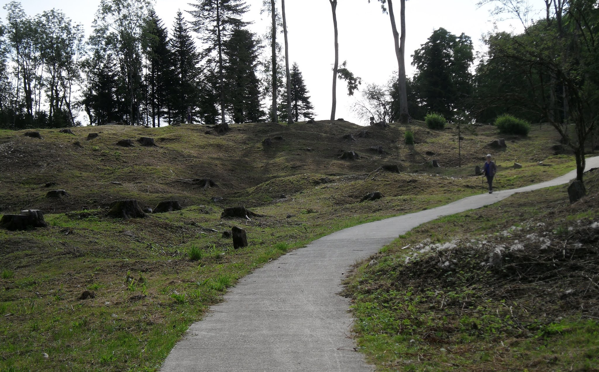
The grounds of Fort Douaumont. The ground still shows the
craters and hills created by the intensive shelling during the war.

 Standing atop the existing Fort. Craters are visible
everywhere here as well.

Glad that I don't have to use the 1917-era
toilets.

Our guide Ingrid and Pat in the damp
interior of the Fort.

The "Wounded Lion", a memorial to the defenders of 
Fort Souville, in particular, the 130th Division.


Destroyed village Fleury-devant-Douaumont. Markers note where
different buildings used to stand. It's probably not a surprise that
the village didn't make it--it changed hands sixteen times between
June and August 1916.

Fleury was a farming community. The evidence of the 
bombardments is still very evident and would have made
post-war agriculture impossible.

One of the primary memorials of the Battle of Verdun in particular, and The Great War in general, is the Ossuary of Douaumont.  The bombardments during the battle were so fierce and the conditions so terrible, that many soldiers' bodies were obliterated or otherwise damaged so badly that they were unrecoverable and/or unidentifiable. The building was an initiative of the Bishop of Verdun at the time, who thought that there was a need for a central location for entombment of unidentified remains and a place where families of the missing could come to mourn them. This memorial contains the skeletal remains of over 130,000 unidentified soldiers--both French and German--who died on the battlefield during the Battle of Verdun.

The Ossuary of Douaumont. The shape of the building is meant
to represent the hilt of a sword with the blade buried in the ground.
The cemetery in front holds about 15,000 identified French dead.


A portion of the exterior of the building. The small square windows
at the lowest level allow viewing of the skeletal remains. The windows
above are those of alcoves that correspond to sectors
of the battlefield. Remains were deposited under the
alcoves corresponding to the sector where they were recovered.
An area at one end of the building's "arms" is the
depository for remains that are occasionally still found.

A bit macabre, yes, but also incredibly sad to think
how many families never knew for sure what happened
to their loved ones. 

The War Memorial of the Citizens of Verdun who died in both
World Wars. Located in the town of Verdun, the statues represent
the five arms of service of the French Army engaged in the battle of 1916.

Also in town is the Monument to Victory and to
the Citizens of Verdun. It symbolizes the French
victories in 1916 and 1918, and the 
rebuilding of the city.

Despite extensive damage to the city from World Wars I and II, the city has managed to retain some of its older heritage, including:

Notre Dame Cathedral celebrated its
millennium in 1990. It suffered several
bombardments during the First World War.

Porte Chaussee (14th C) was originally part of the
city fortifications in the Middle Ages, and served
as the official entry to the city.

A portion of the wall of the 18th century
Saint Nicolas' Chapel, still bearing the marks
from shells and shrapnel from two world wars.

The 12th century Chatel Gate is the oldest gateway
in Verdun. It used to be joined to protective ramparts.

As we continue north we will never be far from reminders of the terrible wars of the last century. Tonight we are on a dock in the quiet village of  Vilosnes-Haraumont. It, too, suffered bombardment damage in WWI, and is basically a residential community today, but the setting is lovely, sitting as it does in the river valley surrounded by hills. 

X marks our spot today. We continue to descend, although
 at a more relaxed pace than our previous changes in elevation.


Saturday, August 7, 2021

Saint Mihiel

Ah, yes, the Canal de la Meuse is a bit more relaxing than our previous two canals. Less locks, more cruising. It's a "canalized river", which means that we have a mix of canal sections and sections where the river flows with the canal. Because we're traveling downstream, in those sections with the river we actually have a bit of current helping to push us along.

One of the sections where we're cruising on the river. Easy to
tell by the red and green channel markers.

Weir to the left, canal to the right.

We're stopped for a couple of days in the town of Saint Mihiel, about 35 kilometers to the south of Verdun. A Benedictine abbey was first established in the area in 709. Buildings come and go, so no vestige of the original building exists, although Saint Mihiel still has a Benedictine library in the center city whose oldest manuscripts date back to the 8th century. Other churches, abbeys, and convents were established in town at different places and times.

Religious buildings seem to have been the "Infrastructure Programs"
of bygone days. The present Abbaye-Eglise Saint-Michel dates
mostly from the late 17th and early 18th centuries, although the
earliest building on the site was established in the 9th century.

The former Couvent (convent) de Minimes. Founded in the 12th 
century as a Benedictine priory, it was given to the Minimes monks
in 1598. The structure was partially rebuilt at the end of the 16th
or beginning of the 17th century. It was sold after the French
Revolution and converted into a farm that is still privately owned today.

Saint Mihiel was a center of artistic endeavor during the Renaissance. Native son Ligier Richier was a sculptor of some renown during that period, and a previous blog posting mentions his famous work that resides in a church in Bar-le-Duc, the skeletal funerary statue of Rene de Chalon. Richier left notable works related to the "Passion" in the churches of Saint Mihiel.

"Swoon of the Virgin", in Eglise Saint-Michel.

The "Lamentation of Christ", Church of St. Etienne.

The French Revolution diminished Saint Mihiel's role as a seat of culture, law, and learning. It regained some status when it became a garrison town at the end of the 19th century, but two successive German occupations in the World Wars of the 20th century had a significant detrimental effect. Despite significant physical damage from the world wars, Saint Mihiel retains some of the "old".

A mix of older and newer buildings in the center of town

A kinder, gentler gargoyle from 1554: a monkey, with not
a dragon or demon to be seen.

Green algae in a diversion canal once used by 
tanners, and in the background, remnants of the
ramparts that surrounded the town in the Middle
Ages (but were mostly torn down in the 17th C).

Saint Mihiel is particularly remembered for what occurred there during the Great War. The German army captured the town in September 2014. In fact, their push west--before being stopped--created what became known as the St. Mihiel Salient. (In battlefield parlance, a salient is a bulge that projects into enemy territory.) The German-occupied bulge in the front lines prevented the allies from using the Meuse River to reinforce their positions in Verdun with troops and munitions. As was true further west in Europe, trench warfare became established in the area, and bloody battles were fought to try to retake St. Mihiel. It wasn't until September 13, 2018, that St. Mihiel was liberated by U.S. Army General Pershing's First Army in The Battle of Saint Mihiel--the first independent American Army operation of WWI. Sadly, too many vestiges of the horrors of that war still exist.

A French military cemetery on the outskirts of
Saint Mihiel. There is an American military cemetery
in the general area, but too far away for us to bike. 

A "small" cemetery, with just under 4000 dead. In this
cemetery the markers were used mostly for graves of (fully
or partially) identified soldiers; at the top of the hill were
3 ossuaries with the remains of the unidentified (which
number between one and two thousand).

The memorial for the Bois d'Ailly operations
in 1914 and 1915, which didn't accomplish much
militarily, but did result in a lot of casualties. The
gravel area in front is an ossuary for the remains of unknowns.
An inscription reads: "Here lie many unknown French
soldiers who died for the Fatherland".

The area of the "Tranchee de la Soif" (Trench of Thirst). This 
German-fortified trench was captured by the French on May 20, 1915,
but the French were surrounded, cut off from resupply, and surrendered
on May 22, 1915. The name of the trench refers to the fact that the
French troops ran out of water. 

The woods are full of trenches and pits from
shell bombardments.

After a fascinating, but somewhat depressing, time remembering the futility of WWI, it's good to get back to the present.

Cliffs around Saint Mihiel are used for rock climbing. Here, Lon
checks out a potential cave, which turned out not to be one.

A bit of excitement on the river: the sailboat (to the left of the photo)
got out of the channel and went aground. Lon rowed our tender out to 
that boat and took its anchor to a deeper part of the water so that the
boater could winch himself out of trouble.

After a day of projects and chores we will be casting off our lines and cruising tomorrow. As we have many times during this trip, we are hoping the weather forecasts that call for rain are incorrect.


Friday, August 6, 2021

Out of the Marne au Rhin Ouest and Heading . . .

. . . North. The Canal de la Meuse is open again for navigation and the Belgian and Netherlands waterways are navigable, so based on current information we are heading for Maasbracht in the Netherlands. Our main source of concern at the moment is the ever-changing Covid situation and possible impacts on our border crossings into Belgium and the Netherlands. But at the moment the borders are open, so we will go with what "is" rather than what "might be" and hope and pray for the best.

After the last blog posting we cruised six days in a row, so there wasn't much of an opportunity to post any updates until today, when we are taking a day off. And, truth be told, the only really significant "events" of the past few days were (1) reaching the summit of the Marne au Rhin Ouest Canal and going through the 3-mile long Mauvage Tunnel and (2) reaching the end of the Marne au Rhin Ouest Canal and entering the Canal de la Meuse.  Otherwise, it was small things:

Going through a lock and being observed by two
"gongoozlers-in-training."

Finally seeing another boat using the Marne au Rhin Ouest.

A humorous canalside display by a resident of Commercy.

Seeing this on a walk along the canal and 
dreading the cruise through the weed the next day, 
only to be pleasantly surprised that it wasn't
as much of an issue as we had feared.


Park-like moorings in Ligny-en-Barrois.

The only remaining tower from the old (12th or 13th C)
castle of Ligny.

It was on August 2nd that we passed through Lock 1 in Demange-aux-Eaux, thus reaching the summit of the Canal de la Marne au Rhin Ouest. We decided not to try to tackle the Mauvages tunnel after an already long-enough day of cruising, so left it to the next morning.

Approaching the entrance to the Mauvages Tunnel. Back on July
13 we went through the Balesmes Tunnel-also 3 miles long-
so future shorter tunnels should be a "piece of cake."

It took an hour and 15 minutes to get through the
tunnel. A vnf employee accompanied us through
the tunnel by riding an e-bike on the tunnel walkway.
  
After leaving the Mauvages Tunnel we were immediately faced with 12 "down" locks in close proximity to one another before we could moor for the evening in the town of Void. A somewhat tiring experience, but a great feeling when they were all behind us to know that we had finished all of the locks on the Marne au Rhin Ouest.

It was in Void that we had a "small world/what are the odds" experience. We had been tied up at the town's halte fluvial for about an hour when we saw Becky and Dave on the barge "Wanderlust" come cruising from the east into Void. Wanderlust was our immediate neighbor at the marina in Auxonne, so it was an amazing bit of timing to meet up in this small French town.

Dave and Becky on Wanderlust leaving Void
on August 4th to continue cruising west on the 
Marne au Rhin Ouest canal.

We started our cruising on August 4th with a blissful lock-free 7 km/4 miles.

It was great to enjoy the scenery without having to
jump up every kilometer to prepare for a lock.

The random patterns of the hay bales are an example
of AAA: Agricultural Abstract Art.

And, finally, we reached the junction with the Canal de la Meuse and the "left turn" that we had decided upon. 

One small aqueduct just before the canal junction.

It doesn't look like much, but a sharp left turn brought us
face-to-face with the first lock on the Canal de la Meuse . . .

. . . which, with "perfect" timing, had a boat ready
to come out.

We didn't go far on the Canal de la Meuse that first day. Although we immediately had 4 locks to contend with in relatively quick succession, that was somewhat of an aberration. We are finding that the kilometers-to-locks ratio is much greater on this canal as compared to either the Champagne et Bourgogne or the Marne au Rhin Ouest, which means longer, more relaxed cruising between locks and less locks per day. 

Our overnight stop was in the town of Commercy. 

The purple lines cross at our location in Commercy. 

The town has two main claims to fame. First, it was the site of one of the favorite residences of the 18th century King of Poland, Stanislas. Second, legend has it that a well-known French dessert called a "madeleine"--a small, golden sponge cake--originated there in the mid-1700's when "Madeleine", a servant of King Stanislas, offered the delicacy to his guests.

The front of King Stanilas' chateau. The building is largely a
reconstruction, as it was heavily damaged during the German occupation
in WWII.

Lon is dwarfed in the back of the chateau.


The madeleine: tastes like pound cake. One of our
"go to" snacks, it also works well as a quick base
for strawberry shortcake.

We are now moored in the town of Saint Mihiel. We've spent time yesterday and today sightseeing, and we'll still be here tomorrow for light maintenance and other projects. There is significant history from both World Wars in this town and further north. But that is a story for another day.