I've written before about how the number of locks one encounters when cruising can impact trip planning, the length of a cruising day, and the amount of physical energy expended during the cruise. It takes at least 15 minutes to get through a lock, given the slow approach to enter, tying up, gates closing, water filling/emptying, gates opening, and slow departure. Add 5-10 minutes if the lock needs to be prepped, and even more if there's a waiting line of boats. I find locks interesting, and having a "reasonable" number along the way contributes to a positive cruising experience. Too many locks can be physically draining--for CARIB's captain, it requires large amounts of concentration to "grease the entry" into spaces that aren't that much wider than we are (although we have it easy compared to the 38-meter commercial barges that are sized to just fit the dimensions of the Freycinet-gauge locks); for the crew, tossing and tightening the lines that stabilize us in a lock is a good upper body workout that is best experienced in moderate doses.
We are now on the Canal lateral a la Loire, the third of the canals for us on our "tour" of the "Bourbonnais Route." The first, Canal du Loing, was 49 km long and had 19 locks, for a km/locks ratio of about 2.6. Not bad. The Canal de Briare fits 36 locks into its 57-meter length, for a km/locks ratio of about 1.6. A number of these locks came in "chains" of 3 or more locks separated by short distances of canal, and once we got started on a chain, the subsequent locks in the chain were usually ready for us and the eclusiers (where present, especially at the deep locks) were helpful with getting our lines attached. It turned a potentially "painful" experience into a pleasant one. The Canal lateral a la Loire is the longest of the 4 "Bourbonnais" canals, stretching 200-kilometers with only 47 locks along that distance, so it has a very pleasant--dare I say "perfect"-- ratio of 4.25. The last canal, the Canal du Centre, is 112 km long and has 61 locks, so the 1.8 km/locks ratio will have us working harder again.
After we crossed the Briare Aqueduct on Friday, June 28, we had hoped to make our first stop the town of Chatillon-sur-Loire. It had promised to be a pretty little village with a good port, but we were not fortunate in our timing. A lovely open spot along the quay was reserved by a hotel boat that day, and the rest of the port was filled, mostly with what appeared to be long-stay boats. So, we continued on to the village of Beaulieu-sur-Loire. We had to work around a few shrubs to get moored, and the electrical connections were spotty, but it turned out to be a nice stop.
 |
The condition of the quay looks better from a distance than it
did close up, but it did the job. The picnic area was cute and
well-maintained, and it was an easy walk into town. |
Beaulieu was one of many fortified towns in the 11th century. It was closely associated with the canons of Bourges, who exercised both temporal and spiritual authority over the town until the French Revolution.
 |
Left: Sainte-Etienne church had the most unusual pews I'd ever seen:
individually enclosed. I suspect modern churchgoers of the
"that's my pew" mindset would love it.
Right: the church had a very basic interior; the ceiling of the
11th C nave had been covered with lath and plaster.
|
 |
The Sainte-Etienne Church in Beaulieu. The 13th C bell tower did
double-duty as a defensive watchtower for the fortified town.
|
 |
The half-timbered building is the former residence
of the canons of Bourges, and was built in the 14th C.
The square tower behind it was a dovecote of the same era. |
 |
The medieval town didn't need to worry about running out of water.
The fifty-one hamlets that comprise the Beaulieu commune contain
two hundred wells. These three are just a sample of what was in
the town proper.
|
Thunderstorms were in the forecast for later in the day on Saturday, so as we made our decision about where to stop, we thought that it would be nice to have access to electricity. We can function without shore power, but when it promises to be cloudy our solar panels aren't quite as efficient, so the ability to plug into electricity is an "easy button" for us. After weighing the different mooring options available to us within the distance we were willing to travel, we pulled into the village of Léré late morning on the 29th.
Léré had been a port on the Loire for much of its existence, but it also served as a place of refuge for religious relics brought by the canons of the city of Tours who were escaping invading Normans. Some of the monks stayed to form a chapter in service of the collegiate church of Saint-Martin de Léré, and the church gained its reputation because of the sheltering of the relics. Léré was a fortified town as well, its ramparts dating from the 12th-13th centuries, and which have since disappeared.
 |
The rear of the collegiate church. The interior and the 11th C
crypt, where the relics were protected, can be visited as part of
a guided tour from the tourist office. Unfortunately, we arrived
in town too late for the Saturday morning tour, and the next one
wasn't happening until Tuesday. The town was cute, but not so
cute that we were going to hang around for 3 more days.
|
 |
Left: the ornate Romanesque portal of the 11th C, a listed historical monument.
Right: a Gothic portal, part of the renovations in the 14th C.
|
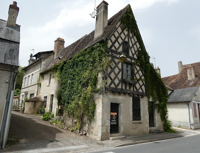 |
The "Joan of Arc House" in Léré. No claims are made that Joan was
actually here, but the lintel over the door has "1421" inscribed, so
the date of construction was close to her era.
|
 |
| The last remaining tower of the city ramparts. |
 |
The 19th C lavoir (wash house) on the left in proximity to the 15th C hospice at right.
|
 |
Visible from the Léré port. If we see any more of these, I may have
to name our summer "The nuclear power plant tour of France." France
gets a lot of its electricity from nuclear power. This plant was near the
town of Belleville-sur-Loire, between Beaulieu and Léré. |
It absolutely poured overnight on Saturday and into Sunday morning. We were happy to wait it out at our mooring until 11 a.m. when the rain mostly stopped and we could continue on.
 |
The things you see when you're waiting for the lock: the Chateau de Peseau, the oldest parts
from the 14th C, is now being run as an events center by the family that owns it. |
Fortunately, there was no repeat for us of the canal closure due to high water that we experienced when we were on the Briare Canal. Boaters elsewhere in the French waterway system haven't been so lucky. Navigation was stopped on the Yonne River, Petite Saone River, and Nivernais Canal due to high water; and on the Burgundy Canal because many trees had toppled into the canal during the storms and had to be cleared. Some of the rivers are still closed, but water levels seem to be dropping.
After a cloudy start, the weather turned lovely during our Sunday cruise. We were now entering into a part of France that we'd visited briefly by car during one of several trips we made to France in 2018 when we were purchasing CARIB III. To say that we were in "wine country" isn't exactly helpful, as much of France is wine country of one sort or another. So, to be more specific, we were entering the region in the eastern part of the Loire valley that produces wines with the "Sancerre" appellation. The wines in this area are primarily white Sauvignon Blancs, with some Pinot Noir. In our previous visit we'd stayed at a small hotel in the town of Bannay--we recognized it as we passed--and spent a day in the hilltop town of Sancerre, from whence the wines get their name. We were ready for a trip down memory lane.
 |
The church in Bannay, Saint-Julien, has an extremely odd profile. The choir, the part
closest to the canal, dates from the 15th C; the pepper pot towers at the other end are 18th C.
The Hundred Years' War and subsequent religious wars will do that to a building. |
A natural stopping place to visit Sancerre would have been the town of St. Satur, but the port doesn't accommodate barges, so we continued a couple more kilometers to the village of Ménétréol. We had a rather exciting end to our cruising day, and not in a good way. We could see that no other boats were parked at the town quay but could also see what appeared to be a rental boat headed our way and was intending to stop at Ménétréol. No problem, there was plenty of room on the quay, but I wondered why Lon was approaching the quay at a relatively fast speed and without his usual finesse. It turns out that the cable running from the throttle control on the flybridge (Morse Control) to the transmission lost screws and became disconnected, thereby keeping us in forward gear and with no way to reverse in order to slow us down. Lon had to use our bow thruster to keep us from crashing into the rental boat, then drop the rear anchor and make an adrenalin-fueled trip to the engine room to manually disengage the transmission. We ended up making a bow-first "crunch" into the far end of the quay, but we'd slowed enough, and we didn't do any damage to either CARIB or the quay. With assistance from one of the men on the rental boat we were able to toss lines to shore and get manually pulled in and moored. Note to selves--make Monday, July 1, a maintenance/recovery day.
Ménétréol-sous-Sancerre has been a village since the 11th C, first under the control of the Abbey of St. Satur, and then in the 12th C under a charter of franchise by the Count of Sancerre. Its main source of wealth through the years has been the cultivation of vines. Ménétréol retains a number of interesting old buildings, and although vineyards grow in close proximity, we didn't notice any active houses for wine production and sale.
 |
| 16th C House with a Tower. |
 |
Lon points to the marker that denotes the water level
during the flood of 1866.
|
 |
The old mill.
|
 |
The 19th C viaduct cut through town; these days it provides
a viewpoint over Ménétréol. |
We spent Monday doing some of the necessary things--grocery shopping for me, and for Lon a trip to the local bricolage (hardware store) for replacement screws to fix the upper helm (ultimately unsuccessful). Until he can find replacement screws, and because we do the bulk of our driving from the flybridge, he "borrowed" screws from the lower helm and got us back in business. That gave us Tuesday as a sightseeing day in Sancerre.
Sancerre sits on a hilltop, 312 meters above the river valley. Its height made it a natural fortress in medieval times, but the addition of a chateau and ramparts enhanced the package. It was a Protestant stronghold during the Wars of Religion in the 16th C., and last year Sancerre commemorated the 450th anniversary of the Siege of Sancerre in 1572-73, during which the Huguenot population held off the Catholic forces of the French king for nearly eight months. Rebellion must run in the veins of the Sancerre population, as Sancerre was a regional command center for the French Resistance in WWII.
Our cycle trip to Sancerre was a bit of a challenge. The first stages weren't bad, but the bike motors weren't quite up to the steep climb at the very end.
 |
We've started the climb, and it's gradual at this point, but we
still have to reach the height of those buildings at the top
of the photo. |
 |
Still climbing--and loving the view of the viaduct amidst
the vineyards.
|
 |
We made it to the top--even if we had to walk the bikes the last
little bit--and can now really look down on things, including
the town of St. Satur and the continuation of the viaduct.
|
 |
The medieval belfry of the Notre-Dame
Church in Sancerre. |
 |
Umbrellas come to Sancerre--but where are
all the shoppers? It was very quiet in town, perhaps
because vacation season hasn't quite started.
|
 |
Left: wine grower's quarter
Right: the street where Jews were forced to live
|
 |
Upper: the last tower remaining from the medieval fortifications
Lower: urban renewal at work |
 |
Wine tasting anyone? The Chateau de Sancerre boutique will be happy to oblige. (Their vineyards
were identified in an earlier photo.) |
We finished the walking tour, amazed at how much we didn't remember from our time in Sancerre six years earlier. The Joseph Mellot shop was close to where we'd parked our bikes, so a quick stop there for a bottle of white and one of rose and we were ready to head back to the boat. July 2nd it may have been, but you wouldn't know it by the cool weather. We appreciated the ease of the downhill return to Ménétréol, and celebrated by giving some business to the local hotel restaurant. Time then to relax and contemplate the next day's cruise, hoping it would be a little less exciting than the last one.


