Friday, September 13, 2019

Normandy 2: Blasts from the Recent Past

Notwithstanding all of the significant historical events that have occurred in Normandy over the past centuries, the Allied military campaign that began with D-Day on June 6, 1944 is still hugely present in the French consciousness. Anniversaries of D-Day and the Normandy campaign that end in "5" or "0" are commemorated more than usual, but even more so those anniversaries that are multiples of "25", such as this year's 75th anniversary.

Many of the larger towns we drove through were
flying this D-Day 75th anniversary flag. 
We kicked off the WWII portion of our trip with an afternoon at the Memorial Museum of the Battle of Normandy in Bayeux. There are dozens of museums in the region devoted to World War II topics, from the general to the very specific. We chose this particular museum because it was specific to the Normandy campaign and we were already in Bayeux for the day. We hoped to get a good understanding of events before actually going to the landing beaches and other pertinent sites. I wish I could say that it was overwhelmingly good, but it was so "text heavy" that we only lasted about an hour before calling it quits.  On our way back to the parking lot we stopped at the Bayeux War Cemetery. With over 4,000 war graves, Bayeux is the largest Commonwealth military cemetery from the Second World War in France.

I need to stop going to British war cemeteries--they always make me cry. Families are allowed to have a message
inscribed on their loved ones' tombstone, and some of the inscriptions are enough to break your heart
Saturday and Sunday, September 7 & 8, were our days for visiting various Normandy battle sites. With an Airbnb centrally located with respect to the landing beaches, we went west on Saturday to focus on America's involvement in Normandy, and as we headed east on Sunday to a different Airbnb we were able to visit sites not in the American zone.

Our first stop on Saturday was the Normandy American Cemetery located just above Omaha Beach at Colleville-sur-Mer. A new Visitor's Center was opened on June 7 of this year, and had a marvelous--NOT text heavy--overview of the campaign and included individual stories of some of the soldiers who fought in Normandy. The cemetery contains the graves of over 9300 soldiers who fell in combat, as well as a "Garden of the Missing" where the names of over 1500 soldiers are engraved.

A quote from General Omar Bradley: "The
battle belonged that morning to the thin, wet line
of khaki that dragged itself ashore on the 
channel coast of France."

English Channel in the background, American flag flying high, gratitude
for the sacrifice, sorrow for the sheer numbers. 
The markers seemed to go on forever.
American grave markers don't contain family statements.
Royd Keys left this flag and message "IN HONOR OF THE
FATHER I NEVER MET." His father (also Royd)
died on  6/6/1944.
After the cemetery we went to Omaha Beach, one of two American landing beaches on D-Day. (Utah Beach, further west, being the second.) The U.S. 1st and 29th Infantry Divisions had a terrible time of it on Omaha Beach. The beach was filled with obstacles, and they had to cross an open area of up to 200 yards and attack up steep bluffs in order to reach the plateau where the Normandy American Cemetery now stands.

Flags to the left, memorial (metal artwork) to the right as Lon walks to
the beach. It was hard to imagine the mayhem of 75 years ago on this
peaceful and sunny day. The beach is used for swimming and other
water activities in the summer months.

The tide was out, which made the beach big and broad and allowed
us to stroll at will. This photo shows a better perspective of some of 
the cliffs that the soldiers landing on the beach had to contend with.

A few kilometers to the west of Omaha Beach stood Pointe du Hoc, a strategic point in the German defenses on the Normandy coast. On D-Day the 2nd Ranger battalion was given the assignment to scale the cliffs and seize the artillery battery located there.

Perspective of the coast looking toward the "point" of
Pointe du Hoc
Former artillery gun emplacement
The land still bears the scars/craters from the Allied naval and air bombardment of the site.
When the Rangers scaled the cliff they discovered that the guns had been moved elsewhere. Fighting was nevertheless intense, and Ranger casualties approached 70 percent. The guns were found and destroyed as the Americans pushed inland.

Our one "non-American" stop of the day was in the town of Port-en-Bessin, on the coast very close to our Airbnb. Royal Marine Commandos captured this small fishing port, which then became an important depot for supplying petroleum to the Allied forces.

Port-en-Bessin: The port--and a several-hundred-years-old Vauban
fortification tower.
Shop fronts in Port-en-Bessin and elsewhere were
decorated with thanks and welcomes
These "WWII Heroes" signs were posted
in most towns to recognize soldiers 
significant to the battle in a particular town.
Peter Ford was with the British commandos
 who captured Port-en-Bessin. He survived
 the war.
Port-en-Bessin's maritime past and present are reflected
in the parish church, filled with ship models. The church
also has a memorial plaque to commemorate those who have
died at sea from 1810 to present day.
On Sunday we checked out of our Airbnb in Commes and started working our way to our new "base" in the town of Honfleur, on the coast about 60 miles east. The driving route allowed us to easily visit two WWII sites of interest to us on that part of the coast.

A mere two miles from Commes stands the site of the German gun battery at Longues-sur-Mer. The only battery to be listed as a Historic Monument, it includes a firing command post and four reinforced concrete pillboxes, each housing a 150 mm piece of long range artillery. It is the only gun battery today to still be equipped with guns from the period. The site also includes a number of individual pillboxes that were formerly equipped with smaller anti-aircraft guns. Some of these smaller pillboxes are part of the "groomed" site and accessible to visit; some are present in the surrounding farm fields, their presence indicated by tufts of vegetation amidst the crops, and are not open to the public--an example of trying to achieve a balance between historical preservation and the needs of present day citizens.

Standing on one pillbox and looking at three blending into the 
landscape. English Channel on the horizon.
The guns were deactivated after capture by British troops 
on June 7, but not completely destroyed.
Lon at Longues-sur-Mer.
The fortifications at Longues-sur-Mer, like those at Pointe du Hoc and numerous other locations, were part of the "Atlantic Wall". Constructed by the Germans between 1942 and 1944, the Atlantic Wall was an extensive system of coastal defenses and fortifications stretching along the coast of continental Europe from Norway to the French border with Spain as a defense against an Allied invasion from the United Kingdom. Historical hindsight shows that as a defensive measure it worked about as well as the post-WWI Maginot Line did to keep Germany from invading France in 1940.

A few miles further to the east stands the town of Arromanches and the British landing site of Gold Beach. Arromanches was liberated on June 6, and two days later the British began installation of an artificial port--a Mulberry Harbor they called "Port Winston"--to facilitate the landing of the soldiers, supplies, and vehicles necessary to continue the push into Normandy. The Mulberry Harbor was actually two artificial harbors that were constructed in England and towed across the Channel. Mulberry A was installed at Omaha Beach and Mulberry B at Arromanches. Each harbor consisted of about 6 miles of flexible steel roadways that floated on steel or concrete pontoons. These "docks" were protected from the force of the sea by line of scuttled ships, sunken caissons, and a line of floating breakwater. A severe storm about two weeks after D-Day destroyed the harbor at Omaha Beach, but the harbor at Arromanches continued to function throughout the Normandy campaign.

Arromanches and "Gold Beach". Traces of the Mulberry Harbor can still be seen offshore. 
A building block of the harbor now deposited on shore.

And yet more remnants of the harbor
There were many more sites we could have visited, but after two emotionally intense days we were ready for a change of focus for the last two days of our time in Normandy. 

Thursday, September 12, 2019

Normandy 1: Blasts from the Distant Past

In the days leading up to our September 4 departure for Normandy, we spent most of our time working on boat projects--Lon dealing primarily with hull preparation for touch-up paint, and me working on re-staining our aft access door and the frames of our deck chairs. We were definitely ready for a break afterwards.

Lon uses our dinghy to get around to the hard-to-reach 
parts of the hull. He is also trying to learn how to "drive"
the boat with the single oar--he's still working on his
coordination, but at least he hasn't fallen in the water.

On Fridays the Auxonne tourist office opens the clock
tower of the cathedral to guided tours. In late August
we finally took advantage and climbed to the top for a
bird's eye view of Auxonne's narrow old streets and steep roofs.
A Sunday afternoon bike ride outside of Auxonne 
took me by this stand of trees playing host to what
I believe is mistletoe. 
The early autumn sunsets are wonderful in Auxonne
As we (i.e., mostly me) were making our travel plans for Normandy, we realized more than ever the truth of the saying, "so many places, so little time." One would think that a week would be more than enough time to see what needed to be seen in a single region of France. It quickly became evident that Normandy was so chock full of places of historical or cultural interest that some difficult choices would have to be made, especially since we refused to: 1) move to a different hotel each night, 2) sightsee from sun-up to sundown, and 3) drive crazy distances each day. (We don't know how the "6 countries in 8 days" tourists do it and maintain their sanity.)

Our only "must sees" for the trip were the American D-Day landing site at Omaha Beach and the American Cemetery nearby, and Mont-Saint-Michel. The itinerary evolved from that, and we continued to fine-tune it even while we were there.

Getting to Normandy by train was a breeze. It involved a couple of changes of train--once in Dijon and once in Paris--but it was SO relaxing not to have to drive 300 miles by car, or to have to deal with airport security.  Public transportation can do only so much however, particularly in rural France. Taking guided tours everywhere held no appeal, so we really needed the flexibility afforded by a car. We've found that it's fairly easy to rent a car at or near railway stations in the bigger towns, and the city of Caen was no exception.

Our base for the first 4 nights was an Airbnb apartment in the village of Commes, just a few kilometers from the water at about the midway point between the American landing zones to the west and the British and Canadian sectors to the east. Although you can't really move in this part of Normandy without "tripping" over World War II sites, we focused our first couple of days on some of the older history of the area.


The Notre Dame church in Commes-not on anyone's
"must see" lists, but very old.  The church tower dates from
the 11th century.
Our next door neighbor at the Airbnb.  The apartment we 
 were in was in a converted stable building that at one time
 served this chateau. There are lots of chateaux in Normandy. 
Our first stop was the town of Bayeux, about a 15 minute drive from where we were staying. A Roman settlement existed in the area from about the 1st century B.C., but the Vikings managed to destroy the existing settlements during their raids in the late 9th century. After being rebuilt, it might have remained just another of France's old towns, except for the fact that in 1066 it was the town from which William the Conqueror--the Duke of Normandy at that time, and cousin to the English king Edward the Confessor--launched his conquest of England after Edward's death. The crowning of the first Norman king marked a turning point in English history, although I suspect that what most Americans know about the Normans in England is derived from watching various depictions of the "Robin Hood" legend (where put-upon Saxons fight against Norman oppressors). Bayeux was the first French town (of significant size) liberated from Nazi occupation during World War II. Its rapid liberation so quickly after D-Day meant that Bayeux was largely spared from the physical destruction that decimated so many towns and villages in this part of Normandy.

Downtown Bayeux. The town contains many
original buildings from the Middle Ages and Renaissance.

Neighborhood of former tanneries (pre-15th C) and
dye works.

The Bayeux Cathedral, consecrated in 1077
in the presence of William the Conqueror by
Bishop Odo, half brother of William. It's still a
working church and is absolutely huge.
The Bayeux Cathedral crypt: columns from
the 11th C, paintings of angels from the 13th C
A main "claim to fame" of Bayeux is the Bayeux Tapestry, created in the late 11th century (and probably commissioned by the House of Norman) as a victor's chronicle of the events surrounding William the Conqueror's conquest of England. As such, it is essentially a work of propaganda to legitimize William's defeat of the English noble Harold (another relative of Edward the Confessor). Not truly a tapestry, in that it is embroidered and not woven, it is an astonishing piece of workmanship. The tapestry is 270 feet long and about 20 inches high. Its scenes include the preparation for invasion, the Channel crossing, the Battle of Hastings (October 14, 1066), and even the appearance of Haley's Comet that year. It is a miracle that it has survived for nearly 1000 years. One of the events that might have led to its destruction was its confiscation in 1792 during the French Revolution for use as a cover for military wagons. It was rescued from one such wagon by a local lawyer who stored it in his house. It is now classified as a "UNESCO Memory of the World."


The Tapestry Museum displays the Bayeux Tapestry in continuous fashion along a curved wall.
The Channel crossing, complete with happy, smiling horses

Haley's Comet (mid-upper part of panel) was probably seen as a bad
omen by soon-to-be-deposed Harold
The battle scenes were rather graphic--dead bodies and chopped off heads are depicted in the lower
part of the panel under the active fighting.
We also explored some of Bayeux's WWII heritage, but that's a topic for the next blog posting, which will focus on World War II Normandy.

On Friday, September 6 we drove nearly 2 hours to the southwestern limits of Normandy to visit Le Mont-Saint-Michel. Anyone who has ever watched a program about travel in France will recognize the iconic profile of this site built on a rocky outcrop in a bay that experiences vast swings in tide.

The flat landscape makes Le Mont-Saint-Michel
visible for long distances. We walked on the pedestrian
path/bridge on our way to MSM; we took a shuttle bus back.
The history of MSM is thought to date back to the early 700's. Changed and extended throughout the centuries, the Mont contains a Benedictine Abbey--dedicated to Saint Michael--built on the top of the rock, a village laid out below, and fortifications surrounding it all. It became an important site of pilgrimage in the Middle Ages. After a stint as a prison from 1793-1863, it reclaimed its religious heritage. The village currently has about 50 full-time inhabitants.

Part of the mystique and the fortress-like character of Mont-Saint-Michel derives from the fact that, in former times, land access to the Mont could only be made at times when the tides were low and the land exposed. The crossing on foot could be dangerous--high tide could come in quickly and powerfully, and at low tide the exposed clay could harbor pools of quicksand. However, in the 1870's a road to the Mont was constructed. Land reclamation projects, the construction of the causeway, and the creation of a dam with flood tide gates all contributed to the gradual silting in of the Mont, such that it lost much of its island-like character. In 2005 the French government began work on a major project to restore the bay. Among other things, the old causeway was removed and a lighter pedestrian bridge installed to allow the currents to flow more freely around the Mont. Restoration work is ongoing.

Modern-day pilgrimage: As one of the top 5 tourist 
destinations in France, MSM has nearly 3 million visitors
a year. 
Entering the lower gates of Mont-Saint-Michel
was a touristic nightmare for us. We knew to
expect crowds, but the reality was horrible
all the same. A bit too "Disney clean" and
too many souvenir shops for our taste.
The narrow streets of medieval MSM were
chockablock with souvenir shops and people. 
And this was September--I can't imagine what
it's like in July and August.
We could escape much of the crowd by
taking the physically more demanding 
"ramparts route" up to the abbey. Great views
up there as well.
Looking up at the Abbey. We went into the
Abbey, and could recognize that it was an
architectural wonder, but it was too crowded
for us to really enjoy the visit.
Looking down at the route into Mont-Saint-Michel.
 The pedestrian and shuttle bus bridge curves to the left,
 then right. The dam is in the distance to the right.
During the abbey's time as a prison, goods were hauled up the
exterior with this chain pulley system that was powered
by 6 prisoners walking inside a huge wheel.
View over the bay from the Abbey. The tide was starting
to come back in.
Mont-Saint-Michel is a UNESCO World Heritage site twice over: First, simply for being what it is and the uniqueness of its location, and second, for being part of the Santiago de Compostela pilgrimage route.

We're glad we made the visit, but the best parts of the day were those where we could escape the full crush of the tourist crowds--the walk over from the mainland and the various views from the ramparts. Our experience and reaction to the crowds has made us reconsider our preliminary itinerary for our upcoming few days in Paris. We had intended to spend a day at Versailles, but in reading several accounts of crowds and long lines--even in September--we are having second (and third and fourth) thoughts about the wisdom of that plan.

Next up--Normandy's D-Day heritage.

Wednesday, August 28, 2019

Settling In

As expected, we've settled into a routine in Auxonne--most days involve an easy start over coffee, shopping for groceries or project items as needed, working on boat projects, light socializing in the port, Lon working on his SSI (StrategicSource, Inc) job responsibilities, and spending quiet evenings reading or on the internet. But a life that is only work would be very dull indeed, so we insert some "fun stuff" into the mix.

On Friday, August 23, our good friends from Haarlem, Netherlands stopped by on their way back to Holland after a 3-week holiday in the west/central and south of France. Joost and Yolanda and their daughters Suze and Rosa spent Friday night and most of Saturday with us. (Yolanda's mom and dad spent several days on the boat with us in mid-June.) We always enjoy their company and their visit provided us with an excellent opportunity for a short cruise on the Petite Saone river.

Yolanda DeJong and Joost Havers
 (back row)
Front row--Suze (l.) and Rosa (r.)
Joost, Lon, Yolanda and Suze on CARIB's back deck
Captain Joost did a great job under Captain Lon's watchful
eye.  The watchful eye wasn't really needed,
 as Joost has much experience in boats.
Auxonne and Port Royal (the marina) are in the background. 
The cruise gave us a first look at what will likely be the start
of next year's cruising route.
Suze and Rosa find that coloring is much better "plein air"
(outdoors)
We had a rental car for the weekend, so on Sunday the 25th we drove to the nearby village of Pesmes. Only a 20-minute drive from Auxonne, it had caught my attention because it is classified as one of "Les Plus Beaux Villages de France" (the most beautiful villages of France). How could we not check that out?

Pesmes occupies a high point on one side of the Ognon River. Its origins aren't exactly known. The first named family appears in records from the 11th century, but Gallo-Roman artifacts found in the area indicate that the village could have been in existence earlier than that. It didn't have an easy history--it was destroyed by the English in 1409 and burned in both 1477 and 1621--nevertheless, several heritage buildings survived.  It has a chateau with origins in the 12th century (and with 16th and 18th century additions); the church of Saint-Hilaire, also begun in the 12th century and with substantial portions from the 13th and 14th centuries; and several buildings of 15th and 16th century vintage.

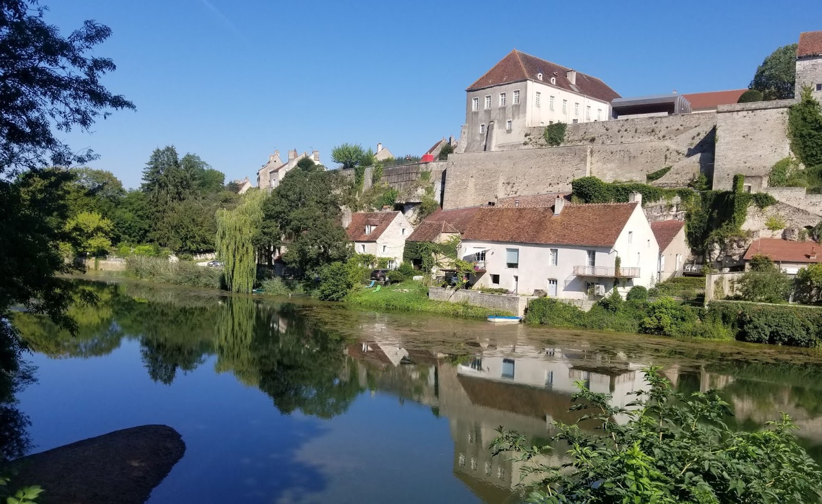
Pesmes on the bank of the Ognon River. The Chateau de Pesmes sits atop the 
walled fortifications. This was our view as we ate lunch at a restaurant on 
the opposite bank of the Ognon.
The view over the lower
 town from the chateau

The church of Saint-Hilaire shows its age. The
shape and decoration of the church tower (toward
the rear) is typical of the Franche-Comte region.
But what about its "beauty" designation? Consider us underwhelmed. Maybe we were expecting too much. It was a nice enough village, but not what we would consider visually stunning. It was also disappointing that, apart from the church of Saint-Hilaire, the primary historic monuments were not open to the public except by appointment.

As it turns out, there are about 160 villages in France with the "most beautiful villages" designation. They are part of an association created to promote the tourist appeal of small rural villages with rich cultural heritage. In order to qualify for the designation, a village must have less than 2,000 inhabitants, have at least two national heritage sites, and have the support of the local village council and a strategy to preserve and promote their heritage. An on-site visit by the association is also part of the evaluation process. Essentially it's an accreditation of sorts that is good for six years as long as the village continues to pay its annual fee and conform with the association requirements. One can't really fault the attempt to bring some attention--and hopefully, tourists and income--to the French villages. Economic and cultural changes, e.g., the influx of large commercial shopping areas on the outskirts of larger towns and the closure of historically important types of businesses (such as sawmills), have been tough on French villages and towns.

We're experiencing a warm spell in these last days of August, but the cool evening temperatures and fog most mornings indicate that fall cannot be far away.

My morning walk today was away from town and strictly rural. The wisps
of fog gave the light a lovely quality.
We had thought that we would be travelling to Spain for a week in September, but the timing didn't work with friends we had intended to visit there. Our "Plan B" is now a trip to the Normandy region of France September 4-11. We thought it would be an appropriate destination during this 75th anniversary year of D-Day, and being able to get there by train is an added bonus. There's a lot to do besides the D-Day beaches, so we'll rent a car once we're there and see what we can fit into a week.